Satellites · 2026-06-28
Radar Doesn't Care About Clouds. A Japanese Startup Just Launched Its 10th Satellite That Sees Through Typhoons, Smoke, and Darkness.
Somewhere over Asia right now, a satellite is firing pulses of microwave energy toward the ground. It doesn't need the sun. It doesn't need clear skies. It doesn't even need to be daytime.
It fires radar. And then it listens to the echo.
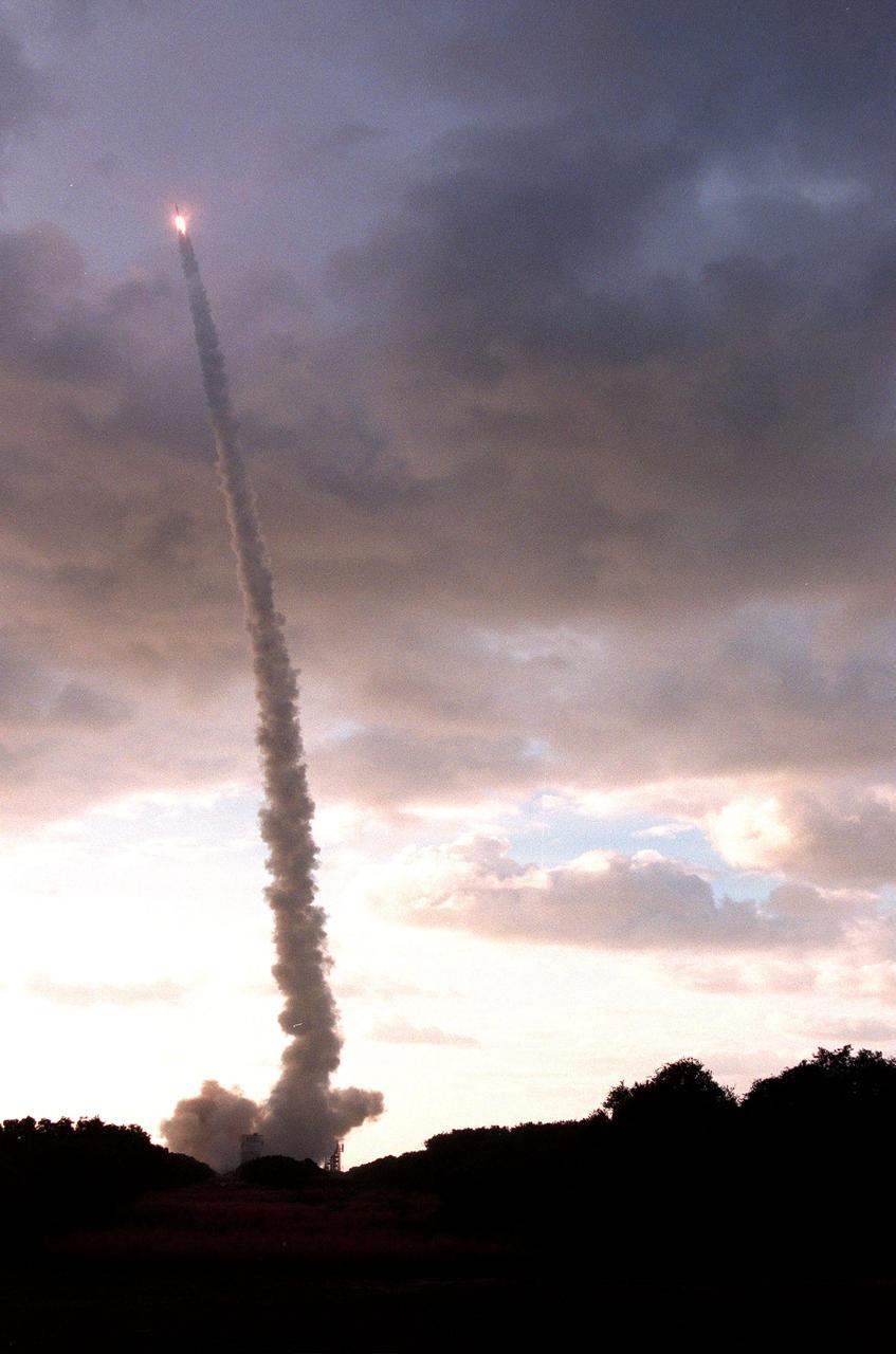
On June 26, 2026, Rocket Lab placed the 10th satellite in Synspective's StriX constellation into low Earth orbit — a growing fleet of radar-imaging spacecraft operated by a Japanese startup that wants to see every corner of Earth, through any weather, at any hour of the day or night. Number ten is up. Thirty are planned.
Here's why that number matters — and why this quiet milestone is more significant than most launches get credit for.
Cameras Are Blind. Radar Is Not.
Every optical satellite in the sky — the ones that take the gorgeous high-resolution photos you've seen of hurricanes, cities, and flooding rivers — has a fatal flaw.
Clouds.
When Typhoon Hagibis tore through central Japan in 2019, flooding entire neighborhoods and killing more than 80 people, most imaging satellites were effectively useless. Cloud cover was total. Emergency responders were navigating with outdated maps. People were waiting to be rescued in places the satellites couldn't see.
SAR — Synthetic Aperture Radar — doesn't have this problem. These satellites fire microwave pulses at the surface and capture the returning signal. Those pulses pass straight through cloud cover, rain, smoke, volcanic ash, and complete darkness. The satellite isn't taking a photograph. It's building a three-dimensional map from echoes.
The images SAR produces look nothing like the satellite photos you're used to. They're monochromatic, textured, almost metallic in appearance. Not the kind of thing you'd post to Instagram. But to a disaster response team trying to locate flooded neighborhoods the moment a typhoon passes? They're worth more than any camera could offer.
What This Technology Can See That Nothing Else Can
Radar imaging reveals things that optical sensors simply cannot detect, no matter how good the camera is.
- Ground movement: SAR can detect land shifting by millimeters between satellite passes — enough to spot a building slowly sinking before it collapses, a volcano quietly inflating before an eruption, or a dam embankment deforming before a failure.
- Ship tracking: Metal hulls reflect radar cleanly and brightly. Even a vessel running dark — no AIS transponder, no lights, trying to disappear into open ocean — shows up as a distinctive bright point against dark water.
- Flood mapping: Water scatters radar away from the sensor. Flooded land turns dark in the image. The exact flood boundary becomes visible within minutes of a pass — not days later when the clouds finally part.
- Deforestation: Forest canopy scatters radar in a unique way. Clear-cut an area and the signal changes measurably — even if the cleared land is hidden under wildfire smoke or persistent overcast.
Intelligence agencies have understood this for decades. The United States, Russia, and China have operated military SAR satellites since the Cold War era. The classified versions can resolve objects far smaller. What's changed is that a Japanese startup just placed its 10th commercial SAR satellite in orbit — and is building 20 more.
The Quiet Race to See Everything, All the Time
Synspective isn't operating alone. The commercial SAR race has become one of the most competitive corners of the satellite industry, and almost nobody outside the aerospace world is talking about it.
Finland's ICEYE operates one of the world's largest commercial SAR fleets. Its radar imagery became strategically important after providing detailed tracking of military movements during the conflict in Ukraine — work that helped ICEYE reach a valuation north of €10 billion. California-based Capella Space can receive a tasking order and deliver SAR imagery within 30 minutes. Canada's MDA Space is building its own 16-satellite radar constellation.
What Japan brings to this race is software. Synspective's pitch isn't just the hardware — it's an analytics platform that converts raw radar imagery into decision-ready intelligence for city planners, insurers, disaster agencies, and infrastructure managers. The satellite is the sensor. The business is the interpretation of what the sensor reveals.
Japan's government has been an early customer, using Synspective data for disaster response coordination after flooding events and to monitor critical infrastructure for gradual deformation. But as the constellation expands, that data will be commercially available to any organization willing to pay for access. You can explore how Earth observation satellites are tracked in real time on the SkyLens live tracker, where all 15,897 catalogued objects appear as they orbit.
The Same Technology That Saves Lives Can Track Anyone
Here's where things get complicated — and worth sitting with for a moment.
The same SAR data that helps flood victims also gives insurers precise flood-boundary maps to challenge claims. The same ship-tracking capability that catches illegal fishing identifies naval vessels that switched off their transponders. The same millimeter-level ground deformation monitoring that warns of building collapse can map which areas around a military installation are being disturbed by construction or tunneling.
Commercial SAR is dual-use by design. The technology is neutral. What it enables is not.
This is, to be fair, true of most Earth observation technology. Optical satellites face the same tension. But SAR removes the last natural barriers — darkness and weather — that previously limited what a commercial company could see and sell. When Synspective reaches 30 satellites, it will have the coverage frequency to revisit any location on Earth multiple times per day, in any conditions.
Synspective has stated its mission as humanitarian and commercial: disaster resilience, infrastructure monitoring, sustainable development. That framing is genuine and the applications are real. It's also incomplete as a description of what the technology enables once it reaches full scale.
Want to understand how different satellite types — optical, infrared, radar — work and what distinguishes them? The SkyLens learn section breaks down the physics behind each sensor type.
Satellite Ten Is a Milestone. Here's Why Twenty Is the Real Threshold.
Ten satellites sounds like a lot. For a SAR constellation, it's still early.
Revisit time — how often a constellation can image the same location — depends directly on how many satellites are distributed across the orbital plane. At ten StriX satellites, Synspective can revisit most locations once or twice per day, which is useful for event response. At twenty, revisit frequency tightens enough that the system stops being a disaster-response tool and starts functioning as something closer to persistent surveillance infrastructure.
That's the threshold where commercial SAR changes character. Not because the technology changes, but because the frequency does. Seeing a location once a day tells you what happened. Seeing it six times a day tells you what is happening.
Rocket Lab delivered satellite ten on June 26. Synspective hasn't published a public deployment schedule for the remaining twenty, but the funding rounds and launch cadence suggest an active program. The pace is deliberate, methodical, and moving in one direction.
Radar doesn't sleep. Radar doesn't wait for clear skies. And there's more of it in orbit every year. For a deeper look at what's overhead right now — from SAR satellites to GPS constellations to debris — more stories on the SkyLens blog track the full picture.
SkyLens editorial — live CelesTrak + NASA/JPL data (15897 objects)
Related stories